Summer 2011
How Maps Made the World
– The Wilson Quarterly
The rise of the map forever changed geopolitics.
It's hard to imagine a world without modern nation-states as we know them—their power, relationships, and, perhaps most of all, borders. But according to Jordan Branch, a political scientist at the University of California, Berkeley, the modern state may be something of a historical accident, an inadvertent byproduct of 15th-century advances in map-making technologies.
During the later medieval period, various authorities ranging from small-time aristocrats to the Holy Roman emperor claimed power over collections of discrete places, not contiguous territories. Sovereignty centered in cities, towns, and villages and radiated outward, with peripheries often ambiguously defined and little heeded. Medieval maps reflected this reality, emphasizing “the importance of places such as cities over the spaces in between them.” During this time, rulers and travelers used texts for many of the purposes maps serve today, such as providing travel directions and demarcating sovereignty in treaties.
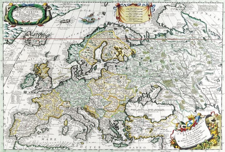
The conceptual shift toward the modern state began in the 15th century, when Ptolemy’s Geography, which showed how to create maps based on a coordinate grid of latitude and longitude, was translated into Latin. This new technology required by its very nature that maps geometrically correlate with the on-the-ground geography. The gaps between power centers could no longer be magically shrunk to insignificance. By happenstance, this shift came just as the printing press was dramatically increasing the quantity of maps in circulation, from a few thousand in the late 15th century to “millions” in the 16th century.
The new maps were not ideal for depicting the old mishmash of authorities that text had ably conveyed. Instead, mapmakers simplified sovereignty’s bounds by drawing clear lines of demarcation between powers. By the mid-17th century, nearly all atlas maps showed boundary lines. (However, these lines did not reflect “actual political practices”—for nearly a century, treaties and other sources of political authority would continue to demarcate sovereignty using text.) Color, added by hand after printing to boost a map’s value, only reinforced the notion of complete, undisturbed sovereignty within borders.
Over time, elites, many of whom collected maps as a hobby, began to see the world as the map-makers drew it, focusing not on where power centered but where it ended. Political reality lagged behind: Branch argues that it wasn’t until the post-Napoleonic treaties and negotiations of 1814–15 that borders—and undisturbed sovereignty within them—became the law of the lands.
THE SOURCE: “Mapping the Sovereign State: Technology, Authority, and Systemic Change” by Jordan Branch, in International Organization, Winter 2011.
Photo courtesy of Flickr/Rosario Fiore